Monday 11th June 1917

Abbeville Communal Cemetery Extension
(1 casualty)The town of Abbeville is on the main road from Paris to Boulogne (N1), about 80 kilometres south of Boulogne. The communal cemetery and communal cemetery extension are located on the left hand side of the road when leaving the town in a north-east direction for Drucat. CWGC direction signs will be found within the cemetery. Enter the Communal Cemetery by the left hand side main gate and follow CWGC signs within the Cemetery. The extension may be entered from the communal cemetery or from the Allée Du Souvenir Francais, where there is car parking available. GPS Co-ordinates: N50.12101, E1.83220

Bailleul Communal Cemetery Extension (Nord)
(7 casualties)Bailleul is a large town in France, near the Belgian border, 14.5 kilometres south-west of Ieper and on the main road from St. Omer to Lille. From the Grand Place, take the Ieper road and 400 metres along this road is a sign indicating the direction of the cemetery. Turn right into a small road and follow for approximately 400 metres. The cemetery is on the right and the Communal Cemetery Extension is at the bottom end.

Boulogne Eastern Cemetery
(1 casualty)Boulogne-sur-Mer is a large Channel port. Boulogne Eastern Cemetery, one of the town cemeteries, lies in the district of St Martin Boulogne, just beyond the eastern (Chateau) corner of the Citadel (Haute-Ville). The cemetery is a large civil cemetery, split in two by the Rue de Dringhem, just south of the main road (RN42) to St Omer. The Commonwealth War Graves plot is located down the western edge of the southern section of the cemetery, with an entrance in the Rue de Dringhen. Car parking is available along the Rue de Dringhen.

Etaples Military Cemetery
(2 casualties)Etaples is a town about 27 kilometres south of Boulogne. The Military Cemetery is to the north of the town, on the west side of the road to Boulogne.

Hazebrouck Communal Cemetery
(2 casualties)Hazebrouck is a town lying about 56 kilometres south-east of Calais and is easily reached from Calais or Boulogne. The Communal Cemetery is on the south-western outskirts of the town. From the Grand Place in Hazebrouck follow the D916 Bethune road. Traverse the first set of traffic lights and the Communal Cemetery will be found 200 metres further along on the right hand side of the road, as indicated by a signpost. The War Graves Plot lies immediately inside the entrance to the cemetery.

Kandahar Farm Cemetery
(1 casualty)Kandahar Farm Cemetery is located 10.5 km south of Ieper town centre on the Niewkerkestraat (N314), a road leading from the N365 connecting Ieper to Wijtschate, Mesen and on to Armentieres. From Ieper town centre the Rijselsestraat runs from the market square, through the Lille Gate (Rijselpoort) and directly over the crossroads with the Ieper ring road. The road name then changes to the Rijselseweg. On reaching the town of Mesen the first right hand turning leads onto the Mesenstraat (N314), which carries on to Nieuwkerke, via the village of Wulvergem. The cemetery lies 1 km after passing through the village of Wulvergem, on the left hand side of Nieuwkerkestraat.
Longuenesse (St. Omer) Souvenir Cemetery
(1 casualty)St. Omer is a large town 45 kilometres south-east of Calais. Longuenesse is a commune on the southern outskirts of St. Omer. The Cemetery is approximately 3 kilometres from St Omer, beside the Wizernes (Abbeville) road (the D928), at its junction with the Rue des Bruyeres. There is a large car park to the rear of the cemetery.

Motor Car Corner Cemetery
(1 casualty)Motor Car Corner Cemetery is located 17 kilometres south of Ieper town centre, on a road leading from the Rijselseweg N365, which connects Ieper to Wijtschate, Mesen, Ploegsteert and on to Armentieres. From Ieper town centre the Rijselsestraat runs from the market square, through the Lille Gate (Rijselpoort) and directly over the crossroads with the Ieper ring road. The road name then changes to the Rijselseweg. 2 kilometres after the village of Ploegsteert lies the left hand turning onto Witteweg (Chemin de la Blanche). The cemetery lies 500 metres after the first right hand turning from the Witteweg on the right hand side of the road.

St. Sever Cemetery Extension, Rouen
(2 casualties)St Sever Cemetery and St. Sever Cemetery Extension are located within a large communal cemetery situated on the eastern edge of the southern Rouen suburbs of Le Grand Quevilly and Le Petit Quevilly. If approaching Rouen from the north, head for the centre of town and cross over the river Seine, following signs for Caen. Follow this route until you get to the 'Rond Point des Bruyeres' roundabout (next to the football stadium), then take the first exit into the Boulevard Stanislas Girardin. The cemetery is 150 metres down this road on the left. If approaching Rouen from the south, follow the N138 (Avenue des Canadiens) towards the centre of town. At the 'Rond Point des Bruyeres' roundabout (next to the football stadium), take the fourth exit into the Boulevard Stanislas Girardin. The cemetery is 150 metres down this road on the left. If arriving on foot, take the metro to St Sever Metro Station, then follow the Avenue de Caen until you get to the Avenue de la Liberation, then take this road and follow this, which will become the Boulevard du 11 Novembre. At the end of this road is the 'Rond Point des Bruyeres' roundabout. Take the first exit from this into the Boulevard Stanislas Girardin. The cemetery is 150 metres down this road on the left.

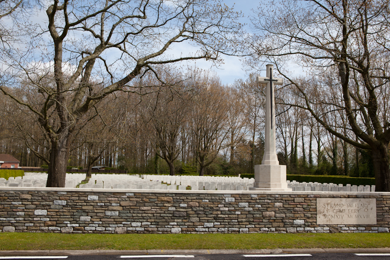
Strand Military Cemetery
(4 casualties)Strand Military Cemetery is 13 Km south of Ieper town centre, on the Rijselseweg N365, which connects Ieper to Wijtschate, Mesen and on to Armentieres. From Ieper town centre the Rijselsestraat runs from the market square, through the Lille Gate (Rijselpoort) and directly over the crossroads with the Ieper ring road. The road name then changes to the Rijselseweg. The cemetery lies on the N365, 4 Km beyond Mesen and immediately before the village of Ploegsteert on the left hand side of the road.

Tower Hill Memorial
(1 casualty)The Tower Hill Memorial commemorates men and women of the Merchant Navy and Fishing Fleets who died in both World Wars and who have no known grave. It stands on the south side of the garden of Trinity Square, London, close to The Tower of London. The Memorial Register may be consulted at Trinity House Corporation, Trinity Square (Cooper's Row entrance), Tower Hill, London EC3N 4DH, which will be found behind the Memorial. Tel: 020 7481 6900.

Trois Arbres Cemetery, Steenwerck
(4 casualties)Steenwerck is a village on the D77 about 6 kilometres south-east of Bailleul, and to the east of the road from Bailleul to Estaires. The Cemetery is situated to the north-east midway between the village and the main road from Bailleul to Armentieres and north of the recently built motorway.

Wellington (Karori) Cemetery
(1 casualty)Wellington (Karori) Cemetery will be found on Karori Road, in the north-western part of Wellington. There are separate 1914-1918 and 1939-1945 services' areas within the public cemetery. (S) at the end of the grave location denotes these. Within the cemetery is the Wellington Provincial Memorial, which takes the form of a marble archway connecting the original Services' Cemetery with the extension which was laid out later. This memorial commemorates servicepeople from the Wellington Military District who died in the 1914-1918 and 1939-1945 Wars and who have no known grave. Also in the cemetery is the Wellington (Karori) Crematorium. The names of 15 casualties from the 1939-1945 War, whose remains were cremated and the ashes scattered, are engraved on a plaque set into the Servicemen's Columbarium Wall in the services' section of the cemetery.

Wimereux Communal Cemetery
(2 casualties)Wimereux is a small town situated about 5 kilometres north of Boulogne. From Boulogne take the A16 to Calais and come off at Junction 4. Take the road to Wimereux north, D242, for approximately 2 kilometres, following the road through the roundabout. Take the first turn on the left immediately after the roundabout and the Cemetery lies approximately 200 metres down this road on the left hand side. The Commonwealth War Graves are situated to the rear of the Communal Cemetery.
